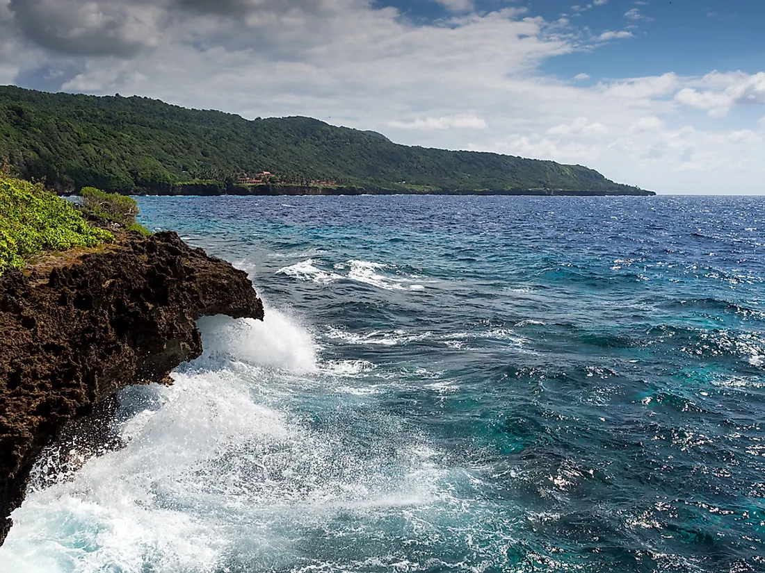
Near Australia is the most interesting Christmas Island, which is actually the top of a huge underwater rock.Moreover, the island is surrounded by a strip of sharp reefs at a distance of approximately 200 m from the coastline.
A Brief History of Christmas Island
The island was discovered during Christmas in 1643. That’s why they gave him that name. An impenetrable reef strip reliably protected the island from European explorers for almost two centuries.
Only in 1887, the Englishman Maclear discovered a convenient bay for ships here. A year later, an English expedition landed in this bay.
It turned out that there are rich deposits of phosphate on Christmas Island. Therefore, England immediately declared the island its property.
Phosphates were mined by a colonial English company that brought workers from China to the island. Only in 1958, Christmas Island received the status of an external territory of Australia.
Tourism on the island
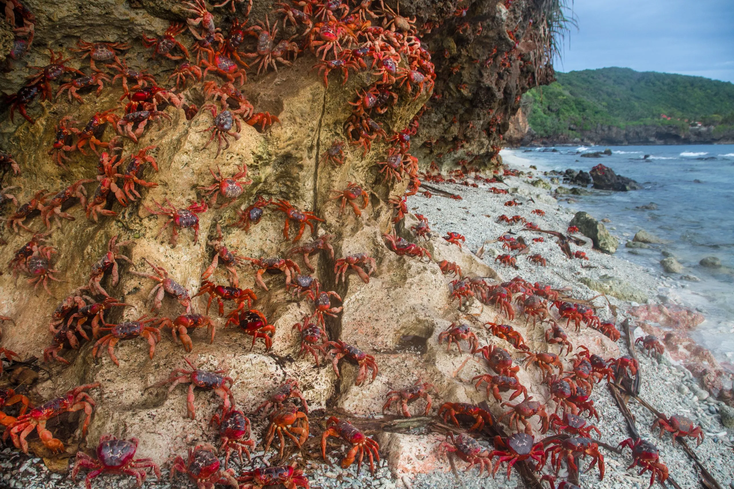
Today, phosphate reserves on the island are almost over. Therefore, it was decided to develop the tourism industry on the island. A reserve was created here to protect the tropical forests, which were badly damaged during the period of active phosphate mining.
It is worth noting here that Christmas Island is located on a major sea route, which greatly contributes to the development of the tourism industry.
In addition, almost all the mines on the island have closed. Having lost their jobs, most of the islanders moved to Australia.
As for the sights of the island, tourists can visit here
- amazing caves,
- Hugh Dale Falls,
- take a walk in the rainforest or
- relax on one of the local beaches.
Location description
Christmas Island is located among the islands of the Line Archipelago, Republic of Kiribati. It is the largest atoll in the world, with a land area of 388 square kilometers and a lagoon area of 324 square kilometers, the height above sea level reaches 13 meters.
Huge colonies of seabirds are concentrated on the island, one of the largest on the planet. There are 5 protected areas on this atoll.
There are several virgin forests on the island, bounded by thickets of pisonia, up to 10 meters high, scaevola takkada, suriana maritime.
Herbaceous vegetation is represented by purslane and fine-tailed. About 5,000 hectares of land are planted with coconut palm.
In 1975, five areas of the island, Cook Atoll, Motu Tabu, Motu Upua, Ngaontetaake and the Northwest Cape, were declared nature reserves, and entry is allowed only with written permission from the authorities.
About 37 species of birds have been observed on the island, 20 of which nest here. Also, the largest number of tropical bird species is concentrated here than anywhere else on the planet. Of the mammals on the island, only the small rat lives.
The population, as of 2005, is 5115 people. Basically, the locals are engaged in growing algae, fishing and collecting pearls, copra production and cultivation of coconuts and breadfruit. Tourism is slightly developed.
In 1956, at a distance of about 50 kilometers from the island, Britain conducted nuclear tests.
Kiribati is the only country in the world located simultaneously in two pairs of hemispheres of the Earth: Northern, Southern, Western and Eastern.
The territory of the state consists of many small islands. Even its capital, South Tarawa, covers several land areas at once.
Kiribati – Pacific nation
Located in Micronesia and Polynesia. Today, out of 33 islands, 13 are inhabited, their area is 812 square kilometers. At the same time, the total territory of the country, taking into account the coastal zone, is 3.5 million square kilometers.
Kiribati includes the largest coral atoll in the world – the island of Kiritimati (Christmas Island) with a land area of 388 square kilometers.
The main city of the state is South Tarawa. The capital is located on the western border of the country, on the Tarawa Atoll.
The atoll itself is visually similar to a triangle
From narrow strips of land with a lagoon inside. South Tarawa occupies only four islands at the base of this conditional triangle. 50 thousand people live in the city, and about 120 thousand in the whole state.
The Republic of Kiribati began to exist only in 1979, when the islands of the Gilbert archipelago gained independence from Great Britain.
The unusualness of the country lies in the fact that the New Year comes first on Christmas Island and a number of nearby islands, and every new day.
The countdown here literally breaks the existing system. Time zones here range from extreme (UTC + 12) to formally not entitled to be (UTC + 14), because the Earth is conditionally divided into 24 zones counted from the zero meridian – up to +12 to the east and -12 to the west.
In 1995, local authorities decided to move the International Date Line. Now, with a number of neighboring countries, the time difference is more than a day – up to 25 hours. Another interesting point is that Christmas Island has its own villages of Paris, London and Poland.
Interesting facts about Kiribati
- The name of the island nation of Kiribati comes from the distorted English “Gilbert Islands”.
- All the islands on which Kiribati is located are atolls.
- Kiribati covers an area of 33 atolls.
- The highest point in Kiribati is 81 meters above sea level. It is located on the Banaba Atoll.
- On the territory of Kiribati there are two freshwater lakes and about a hundred salty ones.
- Kiribati is a member of the United Nations.
- Two of Kiribati’s atolls were once used to test atomic weapons.
- The main problems of Kiribati are overpopulation, lack of fresh water and soil erosion.
- The total population of Kiribati is a little over one hundred thousand people.
- About 90% of the population of Kiribati are representatives of the people of the same name. Its other name is tungar.
- The official language of the country is English, but few people speak it. The majority of the population speaks Kiribati.
- The Kiribati script is based on the English alphabet.
- Kiribati does not have its own army.
- The country has two official currencies – the Australian dollar and the Kiribati dollar equivalent to it.
- The Kiribati one dollar coin has a dodecagonal shape.
- The stamps issued by the country are popular with philatelists around the world and are a significant source of replenishment of the state treasury.
- Kiribati has the second largest exclusive economic zone in the Pacific Ocean – more than three and a half million square kilometers of water.
- Kiribati has two of its own radio stations – government and private.
- Kiribati is the least visited country on the planet by tourists.
- Athletes from Kiribati take part in the Olympic Games.
- Also, the Republic of Kiribati is unique in that it is located in all hemispheres of the Earth at once. Part of
- Kiribati, the Phoenix Islands is the world’s largest marine reserve.